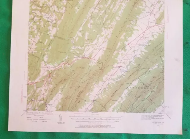
A Great 1939 Orbisonia, Pennsylvania United States Geological Survey Map USGS!
A Great 1939 Orbisonia, Pennsylvania United States GeologicalSurvey Map USGS! A Tremendous USGS Map of the area around Orbisonia, PA (ORBISONIAQUADRANGLE 15-MINUTE SERIES) Including The Cities, Lakes, Rivers andTerritories of the Area! The Map is an Original 1939 Map that Measures 21Inches Tall X 17 Inches Wide!! A Super Map that is Already 80 Years Old and Shows The Area as itwas Prior to Mid Century! A UNITED STATES DEPARTMENT OF THE INTERIORGEOLOGICAL SURVEY! Topography by A. J.Ogle, B.P. Taylor, and C.H. Price. Polyconic Projection. 1927 North American Datum 10,000 –Foot gridbased on Pennsylvania (south) rectanglular coordinate system. 1000 – meter UniversalTransverse Mercator grid ticks, zone 18, shown in blue! Some of the Towns and Points on the Map areThree Springs, FtLittleton, Knobsville, Shade Gap, Rockhill, Orbisonia, Dry Run, Spring Run,Burt Cabins, Maddensville, Fannettsburg, Clear Ridge, Jacks Mountain, BlacklogMountain, Sshade Mountain, Tuscarora Mountain, Kittatinny Mountain, TimmonsMountain, North Mountain, Little State Forest, Knob Mountian, Sheepskin Hollow,Little Aughwick Creek, Sideling Hill Creek, Aughwick Creek, Shade Creek,Blackleg Creek, Locke Craig Run, PLUS lots of Churches and Schools. NO Rips, NO Tears, NO Writing, NO Bends, NO Rust, NO Bites on itof ANY Kind!! NO Creases, NO Dog Eared Corners…Doesn’t look like it was evenused. This is a Beautiful Map (See Photos) TREMENDOUS!! A light smudge alongthe lower right side, but could be matted out. This will be shipped Rolled in a Poster Shipping Tube! NotFolded! This is a GREAT Opportunity to Add This to Your Display! This Would Look Super Matted and Framed and Displayed for All to See! Isthis an Area Where You Live! A GREAT Way to See how the World Around Youhas Changed!! Don't miss your chance to add this to yourcollection. Super Low Price and Shipped With Care! VERY NICE!! Winner will need to prepay and pay $5.95 S&H. International winners may need to pay a little more. Always Happy to Combine Winning Items to Reduce Shipping Costs When Possible. Payment needs to be made within 10 days of auction close when I contact you. Good luck and Thank you.
- Condition: NO Rips, NO Tears, NO Writing, NO Bends, NO Rust, NO Bites on it of ANY Kind!! NO Creases, NO Dog Eared Corners…Doesn’t look like it was even used. This is a Beautiful Map (See Photos) TREMENDOUS!! A light smudge along the lower right side, but could be matted out.
- Date Range: 1939
- Type: Topographical Map
- US State: Wisconsin, Pennsylvania
- Year: 1939
- Cartographer/Publisher: US DEPARTMENT OF INTERIOR
- Original/Reproduction: Original- we do not sell repros or fake old maps
- City: ORBISONIA
- Country/Region: United States of America
- Maker: USGS
PicClick Insights - A Great 1939 Orbisonia, Pennsylvania United States Geological Survey Map USGS! PicClick Exclusive
- Popularity - 2 watchers, 0.0 new watchers per day, 1,619 days for sale on eBay. Good amount watching. 0 sold, 1 available.
- Best Price -
- Seller - 9,197+ items sold. 0.4% negative feedback. Great seller with very good positive feedback and over 50 ratings.
People Also Loved PicClick Exclusive

1907/1939 S. BALTIMORE MD USGS Topographical Geological Survey Quadrangle Map
$42.50 Buy It Now 17d 7h
1939 Lovelace TN Tennessee Geological Survey Quadrangle Topographical USGS Map
$22.73 Buy It Now 27d 9h
Greystone Greene County Tennessee NC 1939 Geological Survey Map 27x22 VG
$51.02 Buy It Now 7d 5h
1939 Lee Valley TN Tennessee Geological Survey Quadrangle Topographical USGS Map
$22.73 Buy It Now 27d 9h
Salina Utah Map United States Geological Survey USGS 1972 41" x 29"
$16.98 Buy It Now 5d 0h


